Ascente Status 10/22/2023

Grading is proceeding at a rapid pace on the Ascente property. The grading for the Sierra Village at the end of Fawn Lane and Brushwood Drive appears to be mostly done. Grading has started along the ridge and saddle areas (Tioga Village). At the southern end of the property next to Patti Lane (Donner Village) there is little grading but there appears to be trenching for a water main. See the photo gallery for new images.

Notes on the Ascente development …

  • The project was approved by the Washoe County Planning Commission in June 2017. The vote was 6-1 in favor of the project despite a detailed presentation (big file) by the residents.
  • The Planning Commission decision was appealed to the Board of County Commissioners in August 2017. The vote was 4-0 in favor of the project despite a presentation describing the public safety issues presented by residents. Bob Lucey, the District 2 Commissioner, recused himself from the vote due to his close ties to this developer.
  • Ascente received extensions in violation of the county policy.
  • The area is zoned 1 home per acre, but the developer got approval for a plan including “clustering” which permits higher density construction in sloped areas. So, if a developer has 100 acres but only 20 acres are level, he can build the 100 homes on the 20 acres and meet the zoning requirement.
  • The first Final Map is for homes at the end of Brushwood Drive. These are located on or near a fault identified by the Nevada Bureau of Mines and Geology.
  • The County Engineer did not respond to a report sent by two geologists describing the fault hazard and fault evidence in the area.
  • The developer is NNV-1 Partners (Michael Barnes). The builder is Toll Brothers.

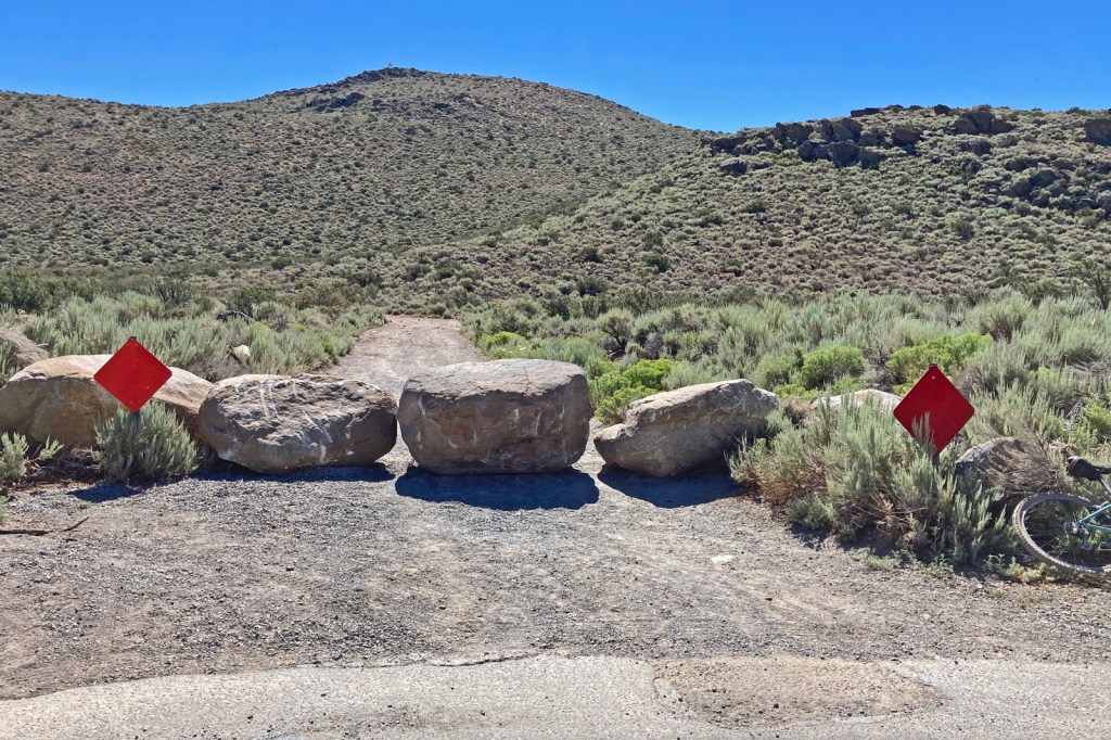
The convenient access for hikers to the Steamboat Hills is mostly closed off.

Ascente Faults

The bottom line … The first Ascente Final Map shows residential construction on a fault identified by the Nevada Bureau of Mines. It is commonly called the Galena Creek Fault. It is drawn as a dashed line.

There’s a lot more to the story, but the county should be concerned that they have accepted a misleading Geotech report for this project.

Principals:

  • NNV1 Partners: developer
  • Toll Brothers: builder
  • Lumos & Associates: Civil engineering firm
  • Gasch Geophysical Services: Soils engineering
  • Fred Saunders: Consulting geologist

Roles

  • A Lumos civil engineer selected the trench locations. Lumos dug the trenches. These trenches were poorly located, poorly dug, and poorly documented.
  • Gasch used seismic testing to determine the structure of the underground rock formations for the purposes of grading. The testing is conducted with a line of vibration sensors and an impact device. It is called a “refraction seismic line” (RS). The results may also detect an earthquake fault. The RS line locations were selected by Lumos.
  • Fred Saunders reviewed the work performed by Gasch and Lumos

The graphic below shows the Ascente Tentative Map superimposed on the fault map using Photoshop Elements. The maps used had consistent North-South orientation. The maps were superimposed using the end of Fawn Lane and the end of Shawna Lane as reference points. See the attached file for the reference materials.

Notes from the graphic

Note-1: Gasch found a fault indication on RS-4. “ … corresponds well to the fault trace previously mapped to this area.” Saunders said “it could be reinterpreted”, but concluded that Lumos should take a core sample to find out. No core sample was taken.

Note-2: Trench 3 is very close to the GC fault. Saunders reported that no fault was found, but there appeared to be fault debris in the trench and in the soil that was excavated.

Note-3: Trench-4 showed evidence of a fault. It was dismissed by Saunders as “too old”, but this is implausible.

The “NEW FAULTS” are ones discovered by the Lumos trenching.

Conclusions

  • The first final map of 5 home sites appears to be situated on top of a major fault identified by the Nevada Bureau of Mines.
  • The Geotech report submitted by Lumos is inadequate in every way. The trenches were not located by a geologist who would know what to look for. The trenches were not dug to industry standards and were not documented (“logged”) to professional standards.
  • Lumos did not follow up with additional core samples or trenches at locations where there was evidence of the Galena Creek fault.
  • The “known fault” at the north end of the property may extend into the property. No trench was dug nor core sample taken to locate the end of this fault.
  • The northern end of the “new fault” in Donner Village was not found. It may extend further into the development.

The deficiencies in the Geotech survey were reported in to the County Engineer and Planning Manager in December of 2017. The local geologists that authored this letter received no reply.

The developer has an incentive to minimize the faults found on the property so as to be able to build the maximum number of homes. The engineering company is paid by the developer. The geologist is paid by the engineering company. There is good reason to be skeptical of such a report.

REFERENCE MATERIALS

Gasch Report

Saunders Report

Lumos Summary

Note: the complete Geotech report includes many pages of soil characteristics, foundation design, and other details not pertinent to the fault issues.

Ascente Developments 11/26/22

It looks like the first construction work is underway on the Ascente property at the Fawn Lane entrance. The initial driveway onto the property now has large aggregate. A dump truck appears with a tractor presumably to fill the large depressions in the dirt road that connects the end of Fawn Lane with the end of Brushwood Way. The conditions placed on the developer by the county include a requirement that Brushwood Way not be used for construction access. The first Final Map approved for this development is close to the end of Brushwood Way, so the builder (Toll Brothers) will need to traverse their property so they would logically improve the road for all the construction equipment.

Additionally, the large boulders that builder had placed at the end of Brushwood Way have been removed. The fence with the padlocked gate remain. This is in violation of the requirement that residents be able to cross from Brushwood to Fawn in the case of an emergency evacuation.

Sierra Reflections Gets 8th Extension

The Board of County Commissioners reversed the decision of the Washoe County Community Services Department (CSD) Director denying the final map of Sierra Reflections development (938 residences on 760 acres in Pleasant Valley) on October 25. The result is that the project which received tentative-map approval in 2006 gets an unprecedented eighth extension of 6 months for “first” final map submittal (redux).

Community Services Director Dave Solaro rejected the final map submittal by World Properties for the Sierra Reflections development on 5/31/2022. Their submittal was only 20 days prior to the recording deadline (6/14/2022) when the statutory requirement is a minimum of 60 days. Furthermore, the final map submittal did not include the minimum content of five residential lots. It was late and inadequate.

The developer had previously applied for an extension that was denied by the Board of County Commissioners on 4/26/2022. Commissioner Lucey made the argument at that time that the project was too old and that the design from 2006 was no longer appropriate. He went on to say that “the project does not know what it wants to be.” and that the developer should submit a new plan for the development and start the approval process over.

Kelly Mullen and Dwayne Smith made a presentation representing the Washoe County staff’s position.

  • The final map was submitted after the deadline.
  • The final map did not include 5 residential lots as required.
  • Did not include an environmental site assessment as required.
  • The developer has not completed their plans for sewer lines.

Garrett Gordon gave a presentation on behalf of the developer.

  • He claimed that the only issue before the board was whether or not to approve the final map. He wanted the final map approved rather than an extension. It is not a time to talk about the development itself or related issues.
  • The developer will work on their part of the sewer design when the county has finished with their part.
  • He claimed that the deadline date required by the CSD is not consistent with the last extension of the deadline (development agreement).
  • He claimed that the lot requirement isn’t specifically for a residential lot and that the lots identified in their application meet the legal requirements.
  • The developer has submitted a petition for judicial review of their appeal. The developer will withdraw this petition if the county will approve the final map as submitted.

Commissioner questions

  • Commissioner Lucey asked about the county’s progress on their portion of the sewer design. Smith said that the county had completed their portion of the design. The county has funding and permits to proceed with construction. They plan to put the sewer construction out to bid in January 2023.
  • Commissioner Hartung asked why the developer needs the county to provide a detailed list of deficiencies when they have not submitted a detailed design yet? The developer should know the requirements for conformance.
  • Lucey asked if additional conditions could be added to the development agreement as part of an extension granted by the county. Nate Edwards (County Attorney) answered that minor conditions could be added regarding the agreement but not conditions regarding the substance of the development.

Commissioner discussion and comments

  • Hartung has a problem with the fact that this project is so old and that so much has changed. “We’ve seen so many changes in the region including traffic patterns …” Repeated extensions mean that we have to retrofit for previous codes.
  • Commissioner Jung made an extended free form comment that proved indecipherable.
  • Lucey made the point that the I-580 highway wasn’t complete in this area when the Sierra Reflections tentative map was approved in 2006. He would like to see a new development agreement with additional conditions of approval.
  • Nate Edwards thinks this appeal is a pretty “novel scenario”. Where an extension is denied and then a final map is submitted of questionable merit. Whatever they decide will not establish a new precedent.
  • Lucey recognized that he had opposed an extension to this project in April. He was frustrated with World Properties.

Vote

  • Lucey made a motion to overturn the decision of the CSD Director and to give the developer 180 days to submit a new final map and then 60 days to have it recorded.
  • All five commissioners (Herman, Hartung, Hill, Jung) voted in favor of Lucey’s motion: it was unanimous.

There was no public comment.

References

AGENDA (see item 16)

VIDEO

Ascente First Final Map

Washoe County filed a final map for Ascente in July from Toll Brothers. It is only for 5 home lots at the end of Brushwood Way on the Ascente property near the end of Fawn Lane. There is no information on the other 220 homes. With this step completed, Toll Brothers can move forward with grading with no further permits or approvals.

A geotech report was included with the final map package to indicate where earthquake faults lie on the property. Homes must be located 50 feet from identified faults. This is a big issue as the Washoe County geologic map identifies several faults on this property and the existence of these faults can wipe out many homesites and reduce the profitability of the development. It therefore behooves the developer to “avoid” identifying these faults and therefore the need to amend their lot locations.

The report file is a combination of different files with many appendices. This is unwieldy. Here are links to the report by Lumos (engineering), Gasch (seismic measurements), and Saunders (consulting geologist). It’s as bad as you might fear. It was the Lumos manager who selected the sites for the exploration trenches and the sites for the refractive seismic lines when it should have been the geologists.

The principal overall problems with the geotech report are the following.

  • The study was done based on an outdated map (1975) when a newer one (2011) was available that showed the locations of the fault systems in the area.
  • The study does not show a fault that has been identified: The Galena Creek Fault that runs along the eastern base of the Steamboat Hills.
  • A major fault appears to end at the property boundary. No effort was made to confirm that it does not traverse the property.
  • The fault trenches were not located properly to identify suspected fault locations on the property.
  • The fault trenches were not dug to industry standards and were not inspected or logged to industry practice.
  • The results of a core sample that indicates a likely fault may have been misrepresented.

Geologists in the neighborhood inspected the trenches after hours to see what work was being done. One of the core samples was left out overnight by the drilling crew allowing inspection by a geologist. A letter was sent to the county engineer, Dwayne Smith, on 12/15/2017 by the geologists indicating the inadequacies of the work performed. There was no response to the detailed letter. A request was made to the county for the Lumos geotech report. It was not provided.

A more detailed review of the Lumos Geotech Report will appear in a later post.

Reference:

Ascente Geotech Report

Geology Concerns for Ascente

Callahan Wildfire Evacuation

This is a guest post by Tom Daly.

When a wind-driven wildfire bears down on your neighborhood, you may only have a few minutes to safely evacuate. Wildfires over the last several years have often blocked the normal vehicular route residents use every day or may find those routes clogged with much more than routine traffic.

So, having a secondary evacuation route should be part of your planning. In the Mt. Rose corridor, housing developments were often planned and approved without those secondary routes or are constrained by closed and locked gates, which complicates the evacuation process.

More recently, the planned Ascente development south of Mt. Rose Highway and east of Callahan Road now owned by Toll Brothers, has exacerbated the problem by blocking the formerly unobstructed secondary access route for both the Fawn Lane neighborhood and the adjacent Callahan Ranch neighborhood. The Brushwood Way (Callahan Ranch) to Fawn Lane connection was blocked by Toll Brothers in July with boulders on the Brushwood Way end.

On Wednesday 7/20/2022 Assistant County Manager Solaro advised me than within two weeks those boulders on Brushwood Way would be replaced by a gate, openable in an emergency, to allow those residents to have their second evacuation route restored. What has happened since? No gate at Brushwood Way as of August 10th.

A second barrier, a temporary fence and gate, chained and padlocked, was later installed at the end of the paved portion of Fawn Lane. Now two barriers to escape for Fawn Lane and Callahan Ranch residents exist.

In a further conversation on Thursday 7.28.2022 with Assistant County Manager Dave Solaro, he advised me that those current and future gates will only be openable by the developer (Toll Bros staff), the Sheriff and his CERT group or TMFPD units. Good luck with that happening in the middle of the night with a wind-driven wildfire roaring down the mountain into those neighborhoods.

At my meeting on August 9th with County Manager Brown, he committed his Emergency Manager to bring forward a solution to this problem in the near term. Manager Brown also indicated that TMFPD Chief Moore is also working this problem. Let’s hope those solutions are implemented before the next wildfire.

Developers’ interests once again trump public safety.

Thomas Daly is a resident of Washoe County and his community is adjacent to the Ascente development.

Ascente Status 7/22/2022

There are new barriers up at the end of Fawn Lane in the form of a fence with a locked gate and boulders at the end of Brushwood Lane. These may be the first activities of the new Ascente owners: Toll Brothers. The route from the end of Brushwood to the end of Fawn is an emergency evacuation route. A concerned resident contacted the assistant county manager (Solaro) regarding this hazard. He said the barrier will be removed within 2 weeks. These barriers will impede pedestrians and cyclists along with motorized vehicles. This part of the property is to be the Sierra Village.

Fawn Lane Fence & Gate

Brushwood Lane

There is no obvious sign of activity in the part of the Ascente property facing Patti Lane (Donner Village).

The Washoe County Planning Department has been contacted to find out if the final map or geotech report (full, partial, or preliminary) have been submitted.

Ascente Sold

The Ascente development was sold by Drakulich Properties (representing NNV-1 Properties, Michael Barnes) to DRP NV2 representing Toll Brothers. When the developer requested (August 2021) that the final map deadline be extended, he claimed that he had an agreement with Toll Brothers to buy the property. The sales price was indicated as “just under $17M”.

This project was approved by the Washoe Planning Commission in 2017 over the strenuous objections of the residents and despite numerous public-safety issues. Residents presented a detailed report on the many violations and hazards that this development represents. Residents appealed to the Washoe Board of County Commissioners who went on to deny the residents’ appeal (document). Issues of flooding, wildfire evacuation, and hazardous traffic were not addressed.

The developer’s earthquake fault map is highly suspect. The area is rife with faults, but none of them go near the development areas according to the documents submitted with the original development application. This is implausible. One known fault was not shown on their fault map. The developer did an unprofessional Geotech survey and did not publish the results. One of the core samples taken indicated fault activity in an area that would be developed. A geologist in the neighborhood sent a letter describing the problems with the developer’s procedures to the county engineer in March 2021. There has been no response.

The public has little say at this point. The plan was approved faults, hazards, and all. There will be no public review. It is now between the developer and county planners. If the planners can be convinced that the plan and further changes are somehow acceptable, the developer can move forward unimpeded. Residents can challenge individual permit applications by the developer. Given that the project was approved, this is not likely to be fruitful. There might be a legal case to be made over a fraudulent Geotech report with a fraudulent fault map. The county and the developer are under no obligation to announce the submission of the Geotech report or to publish it. In Washoe County, there is no process to challenge a fraudulent report.

The buyer bought a property with an approved tentative map which lays out in detail where the homes will be built. This plan is now 5 years old. If the new owner wants to make changes (other than at the detail level), they are required to submit a new tentative map for review and approval. The perspective of the Washoe Planning Commission has changed to be more skeptical of developers’ claims and assurances. A new plan would likely be more benign for existing residents.

A surveyor’s truck was spotted at the entrance to the property at the end of Fawn Lane on 6/22/22.

ThisIs Reno announcement (from developer)

Sierra Reflections Extension Denied 4/26/2022

The Washoe County Board of County Commissioners denied an extension for the developer to file a final map for the Sierra Reflections project until June 14, 2024. The tentative map for this project was approved in 2006 and expired in 2010. It has been repeatedly extended contrary to the intent of the development requirements. It is a “poster child” for the problems of zombie projects. Zombie projects are those that are extended past their deadlines. These projects may or may not “come back to life” many years later.

Tom Daly (a previous Washoe County Planning Commissioner and candidate for NV Assembly-26) wrote a compelling piece about the problems with this extension and the problem of zombie projects in general. Tom sent this to the county commissioners in advance of the meeting and presented it during public comment.

“As I am unable to attend this meeting and testify in person, I am requesting this ‘public comment’ be entered into the formal record for this meeting with copies distributed to each Commissioner.

For the record, I am Tom Daly from the Estates at Mt. Rose and, as a matter of full disclosure, a Republican candidate for Nevada Assembly District 26 in the 2022 primary election.

The proposal to extend the filing deadline for this development is an abuse of process by the developer, aided and abetted by the County Planning Department.  The proposed extension further discriminates against, and makes a mockery of, other developers who ‘play by the rules’ and meet the generous four-year period for filing a final map after approval of their tentative map.

  • Are there any commitments by Washoe County, the Washoe County School District (WCSD), the Regional Transportation Commission (RTC), the Nevada Department of Transportation (NDOT), the Truckee Meadows Fire Protection District (TMFPD) or REMSA to match their ability to provide more services to the massive increase in demand this project will impose?  I see none in the staff report.
  • The leadership of the Truckee Meadows Fire & Rescue (TMF&R) has, on more than one occasion, testified that they lack sufficient resources to serve existing demands for service within their District. 
  • REMSA is so understaffed and equipped that they can no longer serve this area within the recommended 8-minute response time, adding more demands on Truckee Meadows Fire and Rescue (TMF&R) to pick up the slack.  TMF&R has no ambulance capability in the Pleasant Valley area from their two closest stations, #32 East Washoe and #33 Foothill.
  • Where is the traffic analysis to determine the impact on existing roads?
  • Where is the analysis of the impact on schools to determine future capacity or address the issue of schools now at or over capacity?

Given these negative impacts and the lack of information on same in the staff report, I would urge you to deny this request and require a re-submittal for a new tentative map.  Alternatively, and at a minimum, the Commission should add new ‘conditions of approval’ to ensure the final map for this development meets the current editions of the Development Code and the Area Plan.”

This item is a “first reading” and was listed under the “Consent Agenda” rather than “Public Comment”. If the first reading is not “introduced” the motion dies and the extension is denied.

The Washoe County planning manager made a presentation. This included a history of the multiple extensions to the deadline for the final map. The developer claims to be waiting for the required water and sewer capacity to be built for these 938 units.

Commissioner Lucey “I have problems with extending the deadline again for a project that does not know what it is going to be. ” “This is a very large project with a lot of needs that seems very ominous.” “The applicants should reexamine their project and reapply.” “This is not how development should go in our community.”

Commissioner Hartung “There are real problems with water resources in this area.” “Planning has changed. Requirements have changed. Egress [evacuation] has changed.”

Under Public Comment, residents made the following points.

  • Water for Pleasant Valley is already over-allocated.
  • The Planning Staff first reviewed the project in 2004. Much has changed since 2004.
  • This development is a “slippery slope” introducing urban densities in a rural area.
  • This development is not consistent with the Washoe County Master Plan. The Master Plan was changed in 2010, but this development has not been identified as consistent with the current Master Plan.
  • There are 19 parcels with average density of 14,000 sf lots. This is a far cry from this development that will have some condominiums on lots as small as 1,100 sf. Some home parcels are only 6,000 sf.

The developer made the argument that this development was negotiated in lieu of a big resort on the site and that it had been reviewed and approved repeatedly. He claimed that the delays were due to the slow progress on the sewer extension in the area. The development is moving forward with traffic and engineering studies. He asserted that the project fits the area, and that if they had to re-submit it, they would submit the same design.

Lucey commented that this may have seemed to be a great project when it was approved, but that was in 2006. The community and the area have changed since then. The project has not evolved.

Hartung said he’s not in favor of “clustering” [which allows high unit densities on a small fraction of a parcel]. He understands the utility, but does not like it. He wants the parcel-size requirements to be maintained.

No commissioner moved to “introduce” the proposal to extend the deadline. It therefore fails. The existing agreement will expire in June 2022.

AGENDA

MEETING VIDEO

Reno Planning Commission 4/20/2022

The Canyons

The The developer is requesting approval for grading for two water tanks for The Canyons and The Canyon’s Edge developments (developer presentation). The Planned Use Development zoning was approved last year. The plan has changed from a single water tank to using two tanks. There was also a presentation from Reno Planning Staff. The planning department recommended approval. There was no public comment in person or by e-mail. The motion was approved unanimously.

Gateway at Galena

The developer gave a presentation. The plan is for 361 condominiums with both integral and detached garages on 34 acres adjacent to the UNR Redfield Campus on the Mount Rose Highway at the intersection with Wedge Pkwy. The existing zoning is Mixed-Use Suburban. The Master Plan identified it as space for a possible expansion of the Redfield Campus. Their plan is for 11 units per acre which is less than the 30 units per acre typical for this zoning. The buildings will be 3 stories with the ground floor being mostly garages. The Reno Planning Staff had a presentation. The annexation request will go to the Reno City Council in May. Staff recommended approval. The motion was approved unanimously.

Meridian 120

The developer’s attorney came to the Planning Commission requesting that three conditions of approval be approved, amended, or deleted for the Meridian 120 South development. The attorney complained that residents were trying to delay work on the project with an appeal to the Nevada Supreme Court following a loss in district court. The developer is seeking changes to the tentative map approved in 2020. The attorney made a presentation . There was also a staff presentation.

The developer is asking for approval of Condition #28 to rezone 8.3 acres of industrial-commercial to open space. This zoning change will require a master-plan amendment and so will require the approval of the city council as well as the regional planning commission (TMRPA). Staff supports the zoning change and master plan amendment. The recommendation for approval passed unanimously.

The developer wanted the planning commission to drop condition #31 for emergency secondary access to I-80. This condition was applied by the city council. The developer claimed that this access was not necessary and impossible to satisfy. The condition was for the developer to explore the possibility of providing a secondary emergency access to I-80. The developer met with NDOT, and was told that connecting to I-80 was not possible. The development of the adjacent Santerra project makes secondary emergency access available in conjunction with Santerra.

  • Reno Fire Marshall (Palmer): agrees with staff that condition #31 is no longer needed. Developer proposal meets fire code using the Santerra access. Even if the total 3,000 units ($1,600 contribution for each unit) are built, it will not cover the cost of a new fire station, equipment and staffing. [Taxpayers will be subsidizing this development.]
  • The planning commission voted unanimously to recommend to the city council to drop this condition.

The developer is asking that condition #4 be amended for this project. This condition requires that the developer get the Mortensen-Garson Overlay District (MGOD) amended to increase the housing units above the 3,000-unit cap, or to negotiate with other developers working in the area to get additional units under the 3,000-unit cap. The developer wants to build triplex homes in the area zoned Arterial Commercial (AC), but this would exceed the 3,000-unit cap by 285 units. The suggested amendment would indicate that the AC-zoned parcel was exempt from the 3,000-unit cap.

The attorney claimed:

  • Other developers will not trade them units to stay under the 3,000-unit cap.
  • The MGOD cannot be amended at this time due to ongoing litigation.
  • The MGOD cap does not apply to residential units built in the area zoned Arterial Commercial. The cap was intended to apply only to areas zoned as residential. The Arterial Commercial zoning does not have a cap for residential density.
  • Zoning normally allows for up to a 10% density increase which would cover the additional 285 units based on the 3,000-unit cap.

The staff report did not support the claim that the AC-zoned parcel did not fall under the 3,000-unit cap.

Public Comment

Representatives of the Society for the Preservation of Verdi made a presentation. Speakers made the following points.

  • The developer’s argument is a smokescreen intended to exceed the MGOD limit of 3,000 units total.
  • This limit was affirmed by a recent court decision against the adjacent Stan Lucas development.
  • There is an appeal in the Meridian 120 South case before the NV Supreme Court regarding the unit cap.
  • Using the Arterial Commercial zoning for residential makes it subject to the density caps.
  • The AC zoning would only allow 100 units additional: it is not “unlimited” as claimed.
  • The MGOD overlay district takes precedence over Reno zoning.
  • Changes to the MGOD are on hold pending litigation. It might be subject to amendment after the litigation is concluded.
  • It would likely be convenient to residents to have commercial businesses on the frontage road as it is currently zoned.
  • The I-80 overpass and ramps are not to the current standard and will not support greatly expanded traffic.

Commissioner Discussion

The planning commission is making a recommendation to the city council which will have authority regarding the conditions.

  • Commissioner Johnson can’t make the findings for this level of density in this area. He certainly can’t support a proposed increase.
  • Commissioner Gower won’t support it: he does not think the “density bonus” of 10% applies to the MGOD as a whole. He thinks the 3,000 unit cap stands independent of zoning.

The motion passed 4-2 recommending the developer’s request to the city council.

Meeting Video