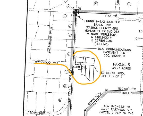
The Reno City Council denied appeals to four tentative map approvals by the Reno Planning Commission. The Daybreak project was approved for a zoning change and a master plan amendment. This is a first step that defines the number of homes and the major characteristics of the development. These changes were challenged at the regional planning board, the city council, and went to court as well. The next step that gets public review is the tentative map approval. This is a plan in greater detail showing lots and streets and drainage easements and information on the utilities. These represent 153 homes; a small fraction of the Daybreak Project (4,000 homes). Reno City Councilmember Jenny Brekhus filed an appeal to these tentative maps that was heard by the city council on 7/21/21. Councilmember Duerr joined remotely. Councilmember Jardon was not present.
There was no public comment with one e-mail received supporting the appeal.
Angela Fuss, Reno Planning Manager, gave the planning staff presentation.
- Discussed the Planned Unit Development (PUD) process for “Village Parcels” where the homebuilder creates the tentative map rather than the developer. Fuss said both “tentative map process” and “parcel map process” making her argument ambiguous.
- Fuss claimed that the PUD handbook is specific about assigning responsibilities and that it is sufficient.
Planning-Presentation_Daybreak_Tentative-Map_Appeal_072121
Michael Pagni (Daybreak attorney) challenged Brekhus’ standing to bring these appeals. Karl Hall (City Attorney) concluded that Brekhus did have standing to appeal.
Councilmember Brekhus made her appeals.
- Fuss was really confusing the issue. The developer is taking a novel approach, sequential parcel-map, that lacks merit or precedent. “You can’t be doing two subdivisions on the same land at once.”
- She used the example of the Double Diamond development where the follow up on the master developer did not occur. There were contentious issues at the end that went to court. She contrasted this with the Damonte Ranch development that had a detailed plan and consistent “build out” over many years without big issues. Ambiguities in the Daybreak plan could leave the city responsible for infrastructure improvements that should be the responsibility of the developer.
- Brekhus played an extended portion of the Reno Planning Commission meeting. The planning commissioners were not familiar with how this should work.
- This is similar to the questionable process that was used for the Stonegate development. At this point, Stonegate has both parcel maps and tentative maps in a way that is redundant. The Stonegate developer tried to get the Nevada law changed to allow his scheme, but he failed. Fuss’s argument that the county does sequential parcel-map process is misleading since the county does not use this for subdivisions.
- The Daybreak developer has made their tentative map and then pulled parcels from it where their tentative map doesn’t apply. You cannot do both parcel maps and tentative maps for the same development: it’s one or the other. “This process is crazy.”
- You have to encompass the entire property in your tentative map.
- The Daybreak zoning-change approval stipulated that there be a detailed process to develop the tentative maps. This process has never been presented.
- The CLOMR** is not done which reviews the flooding risk. The development may be subject to late changes depending on the flooding risk. Who will be responsible for changes that will likely be required by the CLOMR.
Public comment: two residents present supported the appeal.
Pagni gave the developer’s presentation.
- He claimed that the PUD is compliant with code requirements and allows the “sequential parcel map” process. Multiple parcel maps are permitted. “Nothing is improper in this process.”
- Tentative maps and parcel maps can occur simultaneously.
Developer-Presentation_Daybreak_Tentative-Map_Appeal_072121
Council questions:
Councilmember Reese:
- Reese asked Hall about the involvement of his office in reviewing such projects. Hall said his office reviews projects before they go to the Reno Planning Commission including this one. Hall went on to assert that the PUD handbook assigns responsibility so that the city does not end up paying for infrastructure that the developer should have built. Hall said the problems at Double Diamond had to do with maintaining drainage ditches and that the city did not end up paying for this.
Councilmember Duerr:
- Has the 404 permit (flood suitability) been issued by the Army Corps of Engineers. Answer “No”.
- What is the scale of the parcel map: is it an individual home? Fuss “A parcel map is a process that allows a parcel to be divided into up to 4 sub parcels. It can be divided repeatedly by subsequent steps, but these require public review.”
- Why doesn’t the developer make independent tentative maps for each section that they want to sell? Pagni “We needed to make the new parcels that match the tentative maps that we want to sell to builders.”
- Pagni claims this is a “standard” process, but the planning commissioners had to study the details to understand it.
- Duerr is concerned that the flood control design may not be retained as the development is divided into new pieces.
- She asked Brekhus about her concerns. Brekhus replied that the CLOMR is likely to come back with conditions that require changes that have not been anticipated. If the parcels have been divided and potentially sold, who is responsible to implement the changes required by the CLOMR? The descriptions and conditions are too broad and need to be much more specific and binding. Duerr is concerned that by separating the parcels we are losing accountability.
Councilmember Weber
- She made the argument that the Daybreak approval process has already been going on three years. It was not a rushed process as Brekhus claimed. “Time is money” and we need to consider the expense that the process has caused the developer.
Mayor Schieve
- To Brekhus “What is your understanding of the PUD process? It seems to be different than Pagni’s understanding of the process.” Brekhus “I don’t believe it is true that the PUD can be modified. Tentative maps are required after the parcel map division which Pagni says aren’t required. The parcel map process requires all the analysis and review that is required for tentative maps. The project should be returned to the planning commission so that the agreement can be reviewed and the developer can provide a briefing on the process that was requested by Planning Commissioner Marshall.” Pagni claimed that the developer had an informal agreement with the planning department and that this was sufficient.
The votes …
Delgado moved to deny the appeal by Brekhus for item #1, Weber, Reese, Schieve, and Delgado voted in favor, Duerr was opposed. Brekhus could not vote as the appellant.
Delgado moved to deny the appeal by Brekhus for item #2, Weber, Reese, Schieve, and Delgado voted in favor, Duerr was opposed. Brekhus could not vote as the appellant.
Delgado moved to deny the appeal by Brekhus for item #3, Weber, Reese, Schieve, and Delgado voted in favor, Duerr was opposed. Brekhus could not vote as the appellant.
Delgado moved to deny the appeal by Brekhus for item #4, Weber, Reese, Schieve, and Delgado voted in favor, Duerr was opposed. Brekhus could not vote as the appellant.
**Conditional Letter of Map Revision is a FEMA document addressing hydrologic, hydraulic, and flood issues for a proposed development.
REFERENCE
Staff-Report_Daybreak_Tentative-Map_Appeal_072121
Planning-Presentation_Daybreak_Tentative-Map_Appeal_072121